









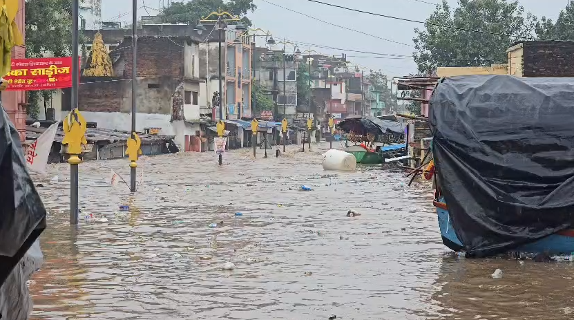
The Mandakini (Paisuni) river at Ramghat in Uttar Pradesh’s Chitrakoot has rarely looked as menacing as it did this monsoon.On Aug 29, the river touched 135.20 metres, surpassing its previous highest flood level of 134.50 metres, recorded in 2003, according to the Uttar Pradesh irrigation department officials.About 7km upstream, across the state border in Satna district of Madhya Pradesh, the same river breached its own 2003 record by an even larger margin, rising to 145.60 metres, 2.95 metres above its previous highest level of 142.65 metres, according to the Central Water Commission.The floods caused widespread devastation along the Mandakini in Chitrakoot district. Around 400 shops at Ramghat were inundated, while the 41-year-old Ramghat-Hanuman Dhara bridge was swept away.Roads, bridges and parts of the Satna-Manikpur railway line were submerged, disrupting traffic and affecting at least 40 trains.Electricity infrastructure suffered extensive damage, leaving several areas without power for nearly 48 hours. The floods also affected villages across the region, prompting the evacuation of 400 people from 16 villages in the district.The devastation raised an obvious question. Why did a relatively small river rise extraordinarily? The answer lies in the river gauge.Gauge records show how unusual the surge was on Aug 29. The Mandakini, whose low water level is 123.5 metres and danger level is 126.5 metres, stood at 125.7 metres at 6.45am before surging to 135.2 metres by 3pm. In just over eight hours, the river rose by about 9.5 metres.Between Aug 17 and Sept 3, the river also crossed the danger mark 11 times.“The flood was not caused by rainfall spread evenly through the day. It was triggered by exceptionally intense rainfall during a few critical hours across the Mandakini catchment. Climate change, shrinking floodplains and decades of human intervention are making even relatively small rivers respond far more violently,” said Awadhesh Kumar Sharma, chief engineer II (investigation & planning, flood), Lucknow.Sharma compared the event with Sept 2, when it rained throughout the day, but the river rose from 126.3 metres at 7am to 129.2 metres at 5.30pm, an increase of 2.9 metres.On Aug 29, despite rainfall being spread over 24 hours, a short period of exceptionally intense rainfall across the catchment triggered a sharp and destructive rise.Notably, both Chitrakoot and Satna districts received exceptionally heavy rainfall on Aug 29, far exceeding their normal daily averages. Chitrakoot recorded an average rainfall of 31 mm, against a normal of 6.2 mm, nearly 400% above normal.Satna district in Madhya Pradesh, where the Mandakini (Paisuni) originates in the Vindhyan hills, received 73.6 mm of average rainfall compared with its normal of 6.6 mm, an extraordinary 1,015% above normal.The intensity of the Aug 29 event becomes clearer when compared with surrounding days. Chitrakoot recorded 20.3 mm on Aug 27, 23 mm on Aug 28 and 13.8 mm on Aug 30, while Satna received 14.8 mm, 6.6 mm and 22 mm, respectively.“The sharp spike on Aug 29 across both the upstream catchment and downstream basin underscores why the river responded with an unprecedented rise,” said Sharma.The Mandakini is not an isolated case. Irrigation department records show several smaller rivers across Uttar Pradesh are repeatedly matching or approaching their historical flood peaks.The Garra in Shahjahanpur equaled its highest flood level (HFL) of 149.80 metres in 2024, matching the record set in 2008.The Khannaut, also in Shahjahanpur, reached its previous HFL of 146.75 metres in 2024, first recorded in 2010.In Moradabad, the Gagan river touched 192.60 metres in 2025, its second highest level after 193.60 metres in 1978. This year, the Karamnasa in Ghazipur rose to 67.40 metres, its second highest level after 68.49 metres in 2021, while the Pandu in Kanpur reached 102.83 metres, second only to its record of 105.66 metres.The Tons (Tamsa) at Prayagraj climbed to 96.14 metres, close to its record of 97 metres in 2018, and the Belan in Mirzapur matched its all-time high level of 139.15 metres this year.The science behind the changing rainfall pattern is relatively straightforward. As the planet warms, the atmosphere can hold more moisture.According to the Intergovernmental Panel on Climate Change (IPCC), the atmosphere’s capacity to hold water vapour increases by about 7% for every 1°C rise in temperature, following the Clausius-Clapeyron relationship.That additional moisture does not necessarily mean more rainy days. Instead, it often results in short, intense bursts of rainfall that can overwhelm rivers and drainage systems.“Instead of steady monsoon rain spread over several days, districts are increasingly witnessing cloudburst like downpours within a few hours. Smaller rivers respond much faster than major rivers because their catchments are limited. Intense rainfall upstream is quickly converted into flash floods downstream,” said Anil Garg, principal secretary, irrigation.The department’s assessment also points to growing spatial variability in monsoon rainfall across Uttar Pradesh. While region, which had a history of below normal rainfall, received exceptionally heavy spells, increasing the risk of flash floods in smaller river basins.Bundelkhand emerged as the starkest example of this uneven pattern. Between June 1 and Sept 27, the region received 1086.3 mm of rainfall against the normal 712.6 mm.Western Uttar Pradesh also recorded slightly above normal rainfall, receiving 771.3 mm against the normal 668.9 mm, or 15 % of normal. Similarly, eastern Uttar Pradesh received 815.2 mm of rainfall against the normal 790.4 mm, or 3% above normal and Central Uttar Pradesh recorded 745.4 mm against a normal of 641.6 mm, equivalent to 16.2% above normal rainfall.ENCROACHMENTS LEAVE NO BREATHING SPACEHeavy rainfall explains why rivers swell. It does not fully explain why floods have become more destructive.Over the years large sections of floodplains that once absorbed excess flows have gradually disappeared beneath housing colonies, roads, commercial developments and agricultural expansion.Village ponds, wetlands and seasonal depressions that traditionally stored runoff have either been encroached upon or silted up, leaving rivers with little room to expand during heavy rainfall.“The unusually high floods being witnessed in several of Uttar Pradesh’s small rivers are not the result of a single factor. It should be understood as the outcome of an interaction between extreme rainfall, the physical characteristics of river catchments, and increasing human modification of the landscape,” said Prof Mahesh Thakkar, director, Birbal Sahni Institute of Palaeosciences (BSIP).“What is changing is not only the total seasonal rainfall, but also the occurrence of short-duration, high-intensity rainfall over relatively small catchments, which can generate a rapid flood response,” he said.“When intense rainfall follows days or weeks of previous rain, the soil is often already saturated and can hardly absorb additional water. Most of the rainfall is therefore converted directly into surface runoff. Small river basins, with their limited catchment areas, narrower channels and lower storage capacity, respond faster than large river systems. This is why a few hours of exceptionally heavy rainfall can produce an unusually high flood,” he said.“Human activities can further amplify this process. Rapid urbanisation, expansion of roads and built-up areas, encroachment on floodplains, loss of wetlands and ponds, drainage congestion and, in some locations, sedimentation that reduces channel capacity all limit the landscape’s ability to absorb, store and safely convey excess water. However, the contribution of factors such as siltation, embankments or hydraulic structures must be established through site specific scientific investigations rather than assumed,” Prof Thakkar said.“The repeated approach to or crossing of historical high flood levels in different rivers is scientifically significant, but it would be premature to attribute every such event solely to climate change. A comprehensive assessment of long-term rainfall intensity, river discharge, sedimentation, channel morphology, land use changes and hydraulic structures is necessary to determine the relative contribution of climatic and human-induced factors,” he pointed out.“The issue is not merely high rainfall, but that it is becoming more intense over shorter periods while catchments have become less capable of absorbing and managing that water,” he added.Prof Dhruv Sen Singh from the department of geology, University of Lucknow, who has done extensive work on rivers in Uttar Pradesh, said: “Floods are natural events. They become a disaster only when people and infrastructure are exposed to them. Rivers have flooded for centuries, cloudbursts have occurred in the past, and landslides are not new. What has changed is human intervention. We have narrowed river channels with embankments, reduced their natural water holding capacity through encroachment and sediment deposition, and allowed settlements to expand into floodplains.”“Small rivers are vulnerable because these have limited capacity to store water and fill up rapidly during intense rainfall. Once their carrying capacity is exceeded, the excess water spreads destructively. So, the problem is not merely extreme rainfall, but the shrinking capacity of rivers to accommodate it,” he said.Recognising the growing vulnerability of floodplains, the Govt of India, amended the River Ganga (Rejuvenation, Protection and Management) Authorities Order, 2016 on Aug 10, 2026.The amendment introduced clearer legal definitions for ‘active flood plain’ (the area of Ganga or its tributaries which comes under water due to floods corresponding to a one in five-year return period), ‘regulatory zone’ (area of flood plain covered by floods between one in five-year return period and one in 25-year return period) and ‘warning zone’ (area covered by floods between the one in 25-year return period and one in 100-year return period), and emphasised maintaining riverbanks and floodplains to preserve their natural groundwater recharge functions and reduce environmental pressures.“Although the notification specifically concerns the Ganga and its tributaries, it reflects a broader policy shift towards protecting floodplains from unchecked encroachment. Preserving floodplains is now as important as strengthening embankments,” said Awadhesh Kumar Sharma, chief engineer-II (investigation & planning, flood).A WARNING FROM SMALL RIVERSThe irrigation department has recommended prohibiting construction in frequently flooded areas, restoring village ponds and wetlands, keeping natural drainage channels free from encroachment and promoting land use that allows excess water to spread safely instead of forcing it into constricted river channels.For years, discussions on floods in Uttar Pradesh have largely centred on the Ganga and Yamuna. The Mandakini’s rise suggests smaller rivers deserve equal attention, because their limited catchments make them highly sensitive to sudden rainfall.“The Mandakini’s new record is more than a statistic. It signals how changing climate is increasing rainfall intensity, encroachments and human settlement are shrinking floodplains, following which these small rivers are responding with unprecedented surges. Urban planning must align with river behaviour, and floodplains must be protected along with wetlands,” said principal secretary, irrigation, Anil Garg.